Week 2 Reflection
This week we looked at how othering is created by white Supremacy and we specifically looked at Algiers and Le Corbusier’s Plan Obus. “ In part stemming from his mission to redesign the city, his analytical observations were keyed to vernacular urban and architectural forms. He did not, as in Istanbul, indulge in speculations about society or religion, neither did he record eyewitness accounts of religious ritual”. His Proposal of an elevated highway arcing between suburban cities and containing fourteen residential levels beneath it. The elevated highway would and bridges planned allowed high-speed travel over the prohibitively narrow and complex streets below. This illustrates that when creating the Plan for the city Corbusier always prioritized the colonizers as the dwellers of the city which creates architecture that only facilitates to them and their mobility. Similarly, The plan suggested that the business district of the city remain in the Quartier de la Marine, an area for European settlement within the original heart of the city. This was a calculated decision to strengthen and protect the European settlement by permanently associating it with the wealthy business district and to further dislocate the natives from the center.
For instance, the Plan Obus does not consider traditional patterns of living such as the extended family and tribe. One must also consider that all of the modern architecture generated elsewhere meant that modernization came in finished form and there was no need for personalization. An example of that is how there are almost two of each space(e.g women’s and men’s living room) in each building or home because of the gender segregation that exists between the sexes. Another thing that always existed in traditional Muslim households was that the house and the mosque would always be an extension of each other whereas modernity changed the way those two spaces were separated and treats a mosque as if it was a different and separate space, ignoring the fact that for hundreds of years it was attached to the house. Today, Western architectural styles dominate architecture on a in the global south . Over time many adopted a “West-is-best” view since modernity and progress became connotations of Western techniques. In addition, architects from the region were either educated in the west or locally by western scholars whom only taught Western architectural theories and as a result continued to transfer Western styles and materials to the region regardless of cultural or environmental needs.
Week 3 Reflection:
The author Britton-Purdy demonstrates the relationship between social justice and environmentalism“ the contemporary policing of racialized spaces—all can be understood not only as battle lines in freedom struggles but also as unacknowledged elements of urban ecology, a denial of mobility, a constraint on access to space.“ this illustrates that Although our urban form is shaped by many things , this week we explored how they are structured by policymakers. Similarly in the New York Times Text on Traffic in Atlanta also demonstrates how traffic and segregation are connected. “For much of the nation’s history, the campaign to keep African-Americans “in their place” socially and politically manifested itself in an effort to keep them quite literally in one place or another. “ This quote demonstrates controlling mobility was a tactic they’ve used since before the civil war as “white masters” kept enslaved African-Americans close at hand to coerce their labor and that started in the 40s with the creation of the highway system which in itself which slipped predominantly black communities.
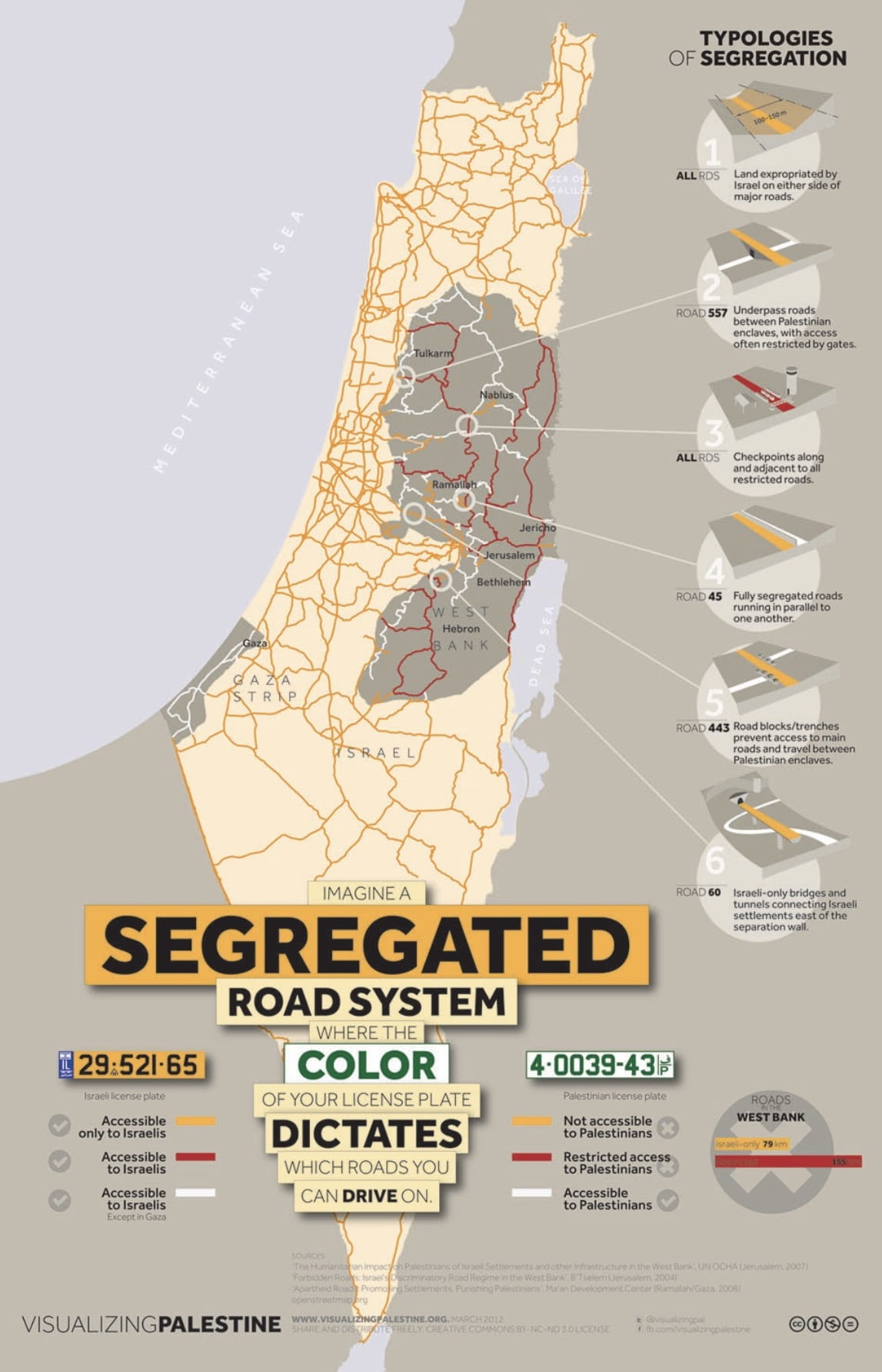
Similarly in the Middle East today, Palestinian residents were subjected to institutional discrimination and exclusion. This was done through the legal military regime that governed areas inhabited by the Palestinians. In recent times, Israel has used strategic ways to use infrastructure and the urban form to help expand the illegal Israeli settlements are created on highways to give advantage to the Israeli citizens and facilitate an easy system for movement as illustrated in the map below as all the roads are in the blue colored territory . However Palestinians face a different reality where there are checkpoints all over the terrain where Palestinians must be searched or encounter roads that only facilitate to the Israelis.
Another example of contemporary policing of racialized spaces is how the neighborhoods in in the West Bank are being built. As we can see through the Atlas photographs there is a common element and a strategy in building the Israeli settlements which is the way they are located on top of hilltops. They are built on these hilltops overlooking the Palestinian land and this is a strategic plan for their ownself protection but to also create hierarchy and to constantly be policing and looking over the Palestinians who have been portrayed in the media as savages and bombers. Furthermore there is an Israeli law that demands the houses to have red roof tops and it is not only to convey a suburban feel but this is also a strategy to allow the military to navigate the landscape from above as a means to control on what they destroy and harm, consequently these rooftops act as a signal to differentiate between the Palestinians and the occupying Israeli community.
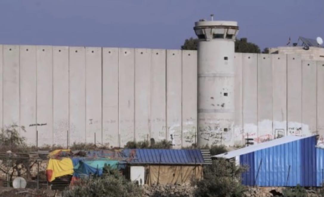
When we imagine borders on a map we imagine a single element that separates two different territories, but in the case of Israel/Palestine there are multiple borders and various border devices. Borders are created in this case through fences around settlements, blockades around Palestinian cities, roads that act as borders or only let in Israeli cars and checkpoints. In addition, the walls are built
with towers which are designed to hide the
presence of surveillance or the presence of the
army which creates an atmosphere of constant
surveillance and fear as one cannot know if they
are being watched and when they are being watched.